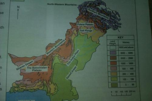
I have to memorize areas which are labelled by white boxes(Northern Mountains, Potwar Plateau, Salt Range, Western Mountains, Indus Plain, Kharan Desert, The Balochistan Plateau, Kharan Desert and Desert Areas) in the picture above..
I don’t understand how I should remember such maps, there are many more maps like this that I have to memorize. Could anyone please tell me how I can use the method of loci here.
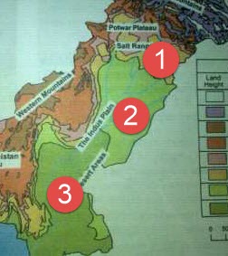
One way to memorize maps is to turn the shapes of regions into images and then connect them all with a story.
Quick examples:
#1: The yellow area under Salt Range looks like an elephant’s head and trunk. Combine the mnemonic image of an elephant with the words “Salt Range”.
#2: The river branches could remind you of the Indus River. If you can’t remember the “plain” part, use a visual mnemonic of an airplane. Maybe a floatplane on the river.
#3: “Desert Areas” sounds like “dessert areas”. You could picture that shape as a melted green ice cream puddle or something like that.
If one mnemonic doesn’t work at first, try another.
You could also just learn countries from (relatively) left to right, top to bottom. Like:
Canada
United states
Mexico - Cuba - The Bahama’s - Jamaica - Haiti - Dominican Republic - San Juan - (a dozen other smaller islands)
Guatemala - Belize -
El Salvador - Honduras
Nicaragua
Costa Rica
Panama
Colombia - Venezuela