I’m in the information collection stage of this, and I’m realizing there’s a lot more to memorize than the basics (countries, states, and capitals) that I initial considered memorizing. There are rivers, mountain ranges, monuments, buildings, bridges, natural wonders like the Grand Canyon, volcanoes, national parks, trails, highest and lowest elevations, length of coastlines, border lengths, when places were settled, most and least populous, longest railways, longest roads, geographic coordinates, area of land and water, and many more statistics.
How much detail did you memorize? What was useful and what wasn’t?
How did you organize it? Is it easier to place all the related information in the same palace with its country/state, or is it easier to give each of these their own separate palace?
You should think about what’s important to you and why when it comes to what to memorize.
What is your motivation for retaining this specific knowledge? Will it be helpful to you in some way? Will you be teaching it to others? Is it just collecting knowledge for its own sake, self enrichment? Trying to win a game show or trivia contest? Or just a personal challenge to see if you can do it? Something else?
If you start with the end in mind and work back, you’ll be less likely to have analysis paralysis and it will help you filter the unnecessary and focus on the important pieces.
Something to think about is fluctuation in data and how often or if you want to revise your facts for things like changing populations that may go out of date rapidly. Same for things GDP or quality of life index, any kind of ranking info that can change. Even land area could fluctuate with annexations or invasions…
Its up to you how granular you want to get. Keep in mind that every element that you are looking to store will require X amount of time to create, encode, and review to push it into accurate long term recall. Make sure you are realistic about your available time and mental bandwidth to keep a sizeable project up through completion.
If you’re looking for a starting point and the goal is info about worldwide geography, I’d start with countries in alphabetical order, with their capitol cities. See what kind of time and effort you’ll require to get those in place. If you can use a memory palace approach and use single loci as a base for each country, make each loci fairly sizable and unique so that if you want to continue the project with more layers of detail, there’s room to add imagery without cluttering the space.
It’s easy to be lured into memorizing loads of facts without considering why you need it in memory in the first place. Not all things deserve the time and effort of memorizing. Like you eluded to, it’s all about the usefulness of that information, which I think is a very good measuring stick for what you should memorize.
For me, my own project with geography has simply consisted of memorizing countries, capitals, flags and location of the country. That is a starting point for a general geography memory layer on which to expand and add more details as you see fit.
Excellent advice above! Wanting to echo the idea that what you’re doing it for should shape how you do it and how much detail you try to grab.
I had no geography education in school and felt really ignorant, so I started working on just the countries (and some smaller territories and islands) and their locations. Because my purpose was just to better understand how countries relate to one another geographically (and the geopolitical implications of location, like supply chains, shared borders, etc.), I started by creating an ordered route through the world so each country is followed by one it’s next to. It’s not ideal, but it has helped me begin to get a better picture of the world.
I’m now going back and memorizing what the borders are for each country (clockwise from the northeast) to build a better picture of what’s close to what; eventually I plan to use this mental map to store additional information, but for now it’s just an ordered list of countries.
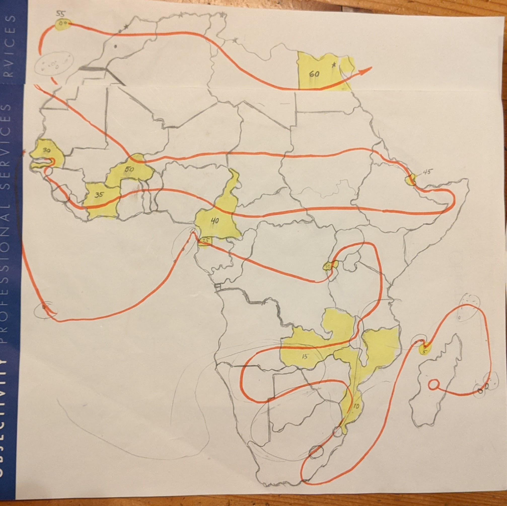
Below is my route through Africa; in my mental map, each tenth country/territory/island has a Major System image on the map (a MooSe in Senegal; a RoSe in Cameroon) – the numbering helps me be sure when reviewing that I haven’t left anything out.
When I went to elementary school in Holland in the early eighties we had to learn an enormous amount of geography facts. So for example we had to learn about 100 cities in America alone. From what I can remember, I used just about every mnemonic you could think of like:
Montvideo (capital of Uruguay) sounds like mond (= dutch for mouth) and video so I imagined something like:
Los Angeles is a beach city, so I imagined angels landing on a beach.
With clusters of cities I woud make up stories that use the concept of hiearchy to code the relative positions; The most northern city would be the leader and the more south a city was , the lower the rank in the hiearchy was. With left and right I would use the idea that the rain comes from the left (from the sea water) and the more to the right a city was the more sunshine it got.
Despite having been the top of my class with regards to these kinds of tests, I can say with great conviction that I think all of this has been a complete waste of my time. There is absolutely zero correlation between what geographical knowledge I have now and what I learned in elementary school. And also, I am more interested to know what the world looks like beyond the great ice rings
And don’t even get me started about how exciting the inside of the earth must be:
I stuck to basics at first. Major cities, languages, people, culture, major geographic locations, etc. Start with the basics and expand as you go.
For example, I do know all countries and where they are. However, while I have the states of the USA down as well, I don’t know the various regions of Japan. I know Kanto, I know Tohoku, I know Hokkaido, because those stood out due to what they contain or because of major events (Tohoku houses Sendai and Fukushima).
That is also how I broaden it. Things happen in the world, and I expand my knowledge. Recent example, Languedoc-Roussillon and Provence-Alpes-Côte d’Azur in France have some weather warnings due to heat, I don’t know where they are. That is reason for me to look for them on a map, and update my knowledge. What is found there? What causes the heat there? Did more interesting things happen there?
Almost nothing outside my local area -and maybe major parts of my country- is actually useful to know to me, I just like to learn more.
I chose to have a mental world map. It took some time, but I can now form a reasonably detailed image of the world in my mind. This gives me all the hooks I need. Something happened in Cuba? No issue, I can find it in my World Map Memory Palace and place events where they happen.
I find this actually pretty funny, because my way to avoid analysis paralysis is to just get started. Start with what I already know, and expand. Try and find out. Find a purpose for the information? Expand the information in that area. Find a way that works to memorize more? Discover why it works and improve the whole thing.
Quality of Life and some other rankings I did add, but more of a scale. Is it Good, Okay, Neutral, Bad or Terrible? A few outstanding ones are highlighed in my memory, but nothing too concrete. What I am mainly curious about is what causes the scores, as that gives me more practical information to work with. Is education bad or is crime high? etc.
One issue I actually found with this is that there are actually multiple lists. 193 UN-members but 195 recognized countries (both additions being observer states for different reasons). Palestine is one of these, but in some lists it is not included, and instead Kosovo is mentioned. So 196? Is the UK one country or mulitple? Is Northern Ireland a country or a province? Same can be asked for the the likes of Kingdom of the Netherlands, France, or New Zealand, all carrying independent “countries” under their wings. China also has Taiwan, Hongkong and Macau, which China counts as divisions and thus part of China while all being in a way separate as well. I believe travelling between the four will get your passport checked and stamped so many times, you will think they are seperate countries. Especially if you are used to Europe and there being barely any passport checks.
There are more, but the many lists, often overlapping, was reason for me to abandon this as a starting point. Because to me as a geology noob, it was confusing. Damn politics.
This would actually be great compared to the uncertain alphabetical list. I’d have to think about how to organize it but that would be much more useful than ABC order.